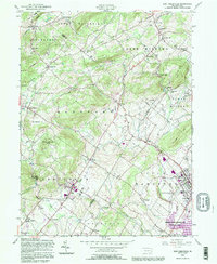
1992 Map of East Greenville
USGS Topo · Published 1995About this map
The boundary lines of Berks, Lehigh, and Montgomery counties converge in this landscape of rolling hills and creek-fed valleys. The borough of East Greenville and neighboring Pennsburg anchor the southeastern corner, where the Perkiomen Preparatory Sch and New Goshenhoppen Ch represent deep-rooted community foundations. To the north, the terrain rises toward South Mountain and the Furnace Hills, shielding smaller settlements like Old Zionsville and Seisholtzville. The hydrology is defined by the Perkiomen Creek and the expansive Green Lane Reservoir, which provides a significant local landmark. Genealogists will find interest in the numerous rural sanctuaries such as St Peters Ch and Salem Ch, as well as quiet burial grounds like Bethesda Cem. The map also captures the cultural era with the presence of a Drive-in Theater near Shimerville, a fixture of mid-century leisure that remained a part of the local geography through the late 20th century.
Find a feature on this map
68 named features on this map. Tap any name to fly to it.
Don’t see what you’re looking for? This feature index may not catch every label — zoom into the map to look around manually.
Map Details
Editions of this 1992 East Greenville Map
This is the sole edition of this map. No revisions or reprints were ever made.
Other maps of this area

1888 · Quakertown
USGS Topo · 1:62,500

1890 · Quakertown
USGS Topo · 1:62,500

1894 · Allentown
USGS Topo · 1:62,500

1894 · Quakertown
USGS Topo · 1:62,500

1902 · Boyertown
USGS Topo · 1:62,500

1902 · Slatington
USGS Topo · 1:62,500

1937 · Allentown West
USGS Topo · 1:48,000

1939 · Allentown
USGS Topo · 1:62,500

1942 · Norristown
USGS Topo · 1:125,000

1942 · Allentown West
USGS Topo · 1:62,500