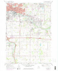
1970 Map of East Lansing
USGS Topo · Published 1978About this map
Michigan State University dominates the northwestern landscape of this survey, with its campus infrastructure including the MSU Observatory and Radio Tower (WKAR) clearly delineated along the Cedar River. To the east, the community of Haslett centers around Lake Lansing and its adjacent Wildlife Lake, while Okemos and Okemos Station mark the transport corridors of the Grand Trunk Western and Chesapeake and Ohio railroads.
Find a feature on this map
86 named features on this map. Tap any name to fly to it.
Don’t see what you’re looking for? This feature index may not catch every label — zoom into the map to look around manually.
Map Details
Editions of this 1970 East Lansing Map
3 editions found
Other maps of this area

1909 · Mason
USGS Topo · 1:62,500

1910 · Lansing
USGS Topo · 1:62,500

1911 · Mason
USGS Topo · 1:62,500

1912 · Lansing
USGS Topo · 1:62,500

1927 · De Witt
USGS Topo · 1:62,500

1928 · Laingsburg
USGS Topo · 1:62,500

1944 · Laingsburg
USGS Topo · 1:62,500

1958 · Grand Rapids
USGS Topo · 1:250,000

1961 · Grand Rapids
USGS Topo · 1:250,000

1962 · Grand Rapids
USGS Topo · 1:250,000
Featured Places
- Lansing, MI
- East Lansing, MI
- Lansing Charter Township, MI
- Meridian Charter Township, MI
- Delhi Charter Township, MI