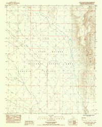
1984 Map of East of Grotto Hills
USGS Topo · Published 1984About this map
Piute Range dominates the eastern horizon of this high-desert landscape, where the rugged slopes meet the broad expanse of Lanfair Valley. The map, produced in the mid-1980s, documents the protected status of the East Mojave National Scenic Area, a designation that reflects the region's transition from a working rangeland to a conservation-focused territory. Scattered evidence of human activity is grounded in several corrals, a guzzler, and industrial traces like a Mine Shaft and Dry Well. The prominence of High Table Mountain West End provides a clear landmark in the north, while a network of 4wd tracks and unimproved roads suggest a terrain navigated by those working the land or exploring its reaches. The presence of numerous washes throughout the valley floor illustrates the drainage patterns characteristic of the arid Mojave climate.
Find a feature on this map
13 named features on this map. Tap any name to fly to it.
Don’t see what you’re looking for? This feature index may not catch every label — zoom into the map to look around manually.
Map Details
Editions of this 1984 East of Grotto Hills Map
This is the sole edition of this map. No revisions or reprints were ever made.
Other maps of this area

1886 · Camp Mohave
USGS Topo · 1:250,000

1892 · Camp Mohave
USGS Topo · 1:250,000

1910 · Ivanpah
USGS Topo · 1:250,000

1912 · Ivanpah
USGS Topo · 1:250,000

1926 · Mohave City
USGS Topo · 1:96,000

1942 · Camp Mohave
USGS Topo · 1:250,000

1942 · Ivanpah
USGS Topo · 1:250,000

1947 · Kingman
USGS Topo · 1:250,000

1948 · Kingman
USGS Topo · 1:250,000

1954 · Kingman
USGS Topo · 1:250,000