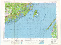
1976 Map of Eastport
USGS Topo · Published 1976About this map
The maritime borderlands of eastern Maine and western Nova Scotia are meticulously detailed in this survey by the U.S. Geological Survey. Centered on the Grand Manan Channel, the map captures the intricate coastal geography of Downeast Maine, from the deep harbors of Eastport and Lubec to the winding reaches of the Machias River. The landscape is a network of coastal settlements and inland lakes such as Gardner Lake and Meddybemps Lake, with the Maine Central RR providing the primary industrial link between timber towns like Cherryfield and Machias. Across the Bay of Fundy, the Nova Scotian shoreline reveals a dense string of Acadian communities including Church Point and Saulnierville. Conservation and history meet at Roosevelt Campobello International Park and the multiple tracts of the Moosehorn National Wildlife Refuge, which dominate the marshes and woodlands near Passamaquoddy Bay.
Find a feature on this map
133 named features on this map. Tap any name to fly to it.
Don’t see what you’re looking for? This feature index may not catch every label — zoom into the map to look around manually.
Map Details
Editions of this 1976 Eastport Map
This is the sole edition of this map. No revisions or reprints were ever made.
Other maps of this area

1902 · Cherryfield
USGS Topo · 1:62,500

1904 · Cherryfield
USGS Topo · 1:62,500

1904 · Bar Harbor
USGS Topo · 1:62,500

1904 · Petit Manan
USGS Topo · 1:62,500

1907 · Eastport
USGS Topo · 1:48,000

1908 · Eastport
USGS Topo · 1:62,500

1917 · Cutler
USGS Topo · 1:62,500

1918 · Machias
USGS Topo · 1:62,500

1918 · Cutler
USGS Topo · 1:62,500

1921 · Great Wass Island
USGS Topo · 1:62,500