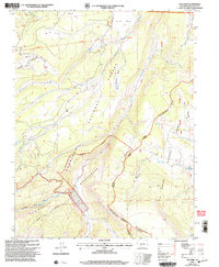
2001 Map of Elk Park
USGS Topo · Published 2005About this map
Eddiesville serves as a small anchor point in this high-altitude landscape, where the Gunnison and Rio Grande National Forests meet along the jagged crest of the La Garita Mountains. The 2001 revision illustrates a complex network of backcountry routes, most notably the Continental Divide National Scenic Trail and the Skyline Trail, which trace the high ridges and drainage divides. Water systems like Cochetopa Creek and Stewart Creek flow through deep-cut basins like Hondo Cañon, defining the movement of early travelers and forest rangers alike.
Find a feature on this map
36 named features on this map. Tap any name to fly to it.
Don’t see what you’re looking for? This feature index may not catch every label — zoom into the map to look around manually.
Map Details
Editions of this 2001 Elk Park Map
This is the sole edition of this map. No revisions or reprints were ever made.
Other maps of this area

1914 · Creede
USGS Topo · 1:125,000

1916 · Creede
USGS Topo · 1:125,000

1945 · Durango
USGS Topo · 1:250,000

1953 · Durango
USGS Topo · 1:250,000

1954 · Durango
USGS Topo · 1:250,000

1956 · Montrose
USGS Topo · 1:250,000

1959 · Montrose
USGS Topo · 1:250,000

1959 · Creede
USGS Topo · 1:62,500

1960 · Montrose
USGS Topo · 1:250,000

1961 · Durango
USGS Topo · 1:250,000