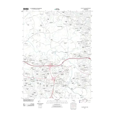
2011 Map of Ellicott City
USGS Topo · Published 2011About this map
The Patapsco River and its numerous tributaries, such as Dogwood Run and Sucker Branch, dictate the landscape of this Maryland suburban corridor at the start of the 2010s. The region is characterized by an intricate network of residential developments including Mardella Run, Kingswood Common, and Offutt Ridge, many of which reflect the modern expansion around Randallstown and Windsor Mill. Along the river's winding path, industrial and logistical history is visible through features like the Daniels Dam and the CSX rail line passing through the Davis Tunnel. Local heritage is preserved in numerous burial grounds, such as Saint Thomas Cemetery and the Bihy Cemetery. A unique commercial landmark, the Enchanted Forest Postal Store, appears near the Howard County Government Complex, illustrating the mix of civic infrastructure and quirky local history in the Ellicott City vicinity.
Find a feature on this map
282 named features on this map. Tap any name to fly to it.
Don’t see what you’re looking for? This feature index may not catch every label — zoom into the map to look around manually.
Map Details
Editions of this 2011 Ellicott City Map
This is the sole edition of this map. No revisions or reprints were ever made.
Other maps of this area

1892 · Laurel
USGS Topo · 1:62,500

1892 · Ellicott
USGS Topo · 1:62,500

1894 · Ellicott
USGS Topo · 1:62,500

1894 · Laurel
USGS Topo · 1:62,500

1894 · Baltimore
USGS Topo · 1:62,500

1894 · Relay
USGS Topo · 1:62,500

1897 · Laurel
USGS Topo · 1:62,500

1899 · Baltimore
USGS Topo · 1:62,500

1904 · Baltimore
USGS Topo · 1:62,500

1906 · Ellicott
USGS Topo · 1:62,500