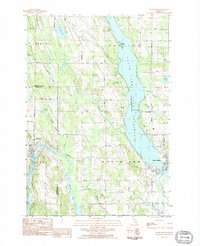
1983 Map of Ellsworth
USGS Topo · Published 1984About this map
Ellsworth and East Jordan anchor this 1983 survey of the northern Michigan landscape where the glacial fingers of the Chain O' Lakes meet the massive South Arm Lake Charlevoix. The village of Ellsworth is situated between St Clair Lake and Wilson Lake, a region defined by a sophisticated network of small inland waterways and marshes that feed the larger South Arm. This map illustrates the transition from the concentrated residential streets of East Jordan to the surrounding agricultural and timbered lands of Banks and Eveline townships.
Find a feature on this map
56 named features on this map. Tap any name to fly to it.
Don’t see what you’re looking for? This feature index may not catch every label — zoom into the map to look around manually.
Map Details
Editions of this 1983 Ellsworth Map
This is the sole edition of this map. No revisions or reprints were ever made.
Other maps of this area

1954 · Central Lake
USGS Topo · 1:62,500

1954 · Charlevoix
USGS Topo · 1:62,500

1955 · Cheboygan
USGS Topo · 1:250,000

1958 · Cheboygan
USGS Topo · 1:250,000

1958 · Bayshore
USGS Topo · 1:62,500

1961 · Boyne City
USGS Topo · 1:62,500

1975 · Boyne City NW
USGS Topo · 1:24,000

1975 · Boyne City NE
USGS Topo · 1:24,000
1983 · Bay Shore
USGS Topo · 1:25,000
1983 · Atwood
USGS Topo · 1:24,000