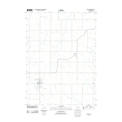
2011 Map of Emerson
USGS Topo · Published 2011About this map
Emerson sits at the southwestern edge of this landscape, serving as a primary hub for this corner of the Nebraska countryside. The town's grid is punctuated by local landmarks like the Emerson Post Office and the neighboring Calvary Cemetery and Rose Hill Cemetery. The surrounding terrain is defined by a dense network of sectional roads and a series of winding watercourses, including the central Elk Creek and the southern Middle Creek. To the northeast, the small settlement of Nacora is noted for the Nacora Post Office, situated where the highway meets Perry Ave. This 2011 survey captures the area's agricultural character, tracing the drainage patterns of Pigeon Creek and North Omaha Creek through a landscape of family-named road corridors and rural burial grounds such as the Jopp Cemetery on the eastern boundary.
Find a feature on this map
40 named features on this map. Tap any name to fly to it.
Don’t see what you’re looking for? This feature index may not catch every label — zoom into the map to look around manually.
Map Details
Editions of this 2011 Emerson Map
This is the sole edition of this map. No revisions or reprints were ever made.
Other maps of this area

1955 · Sioux City
USGS Topo · 1:250,000

1958 · Sioux City
USGS Topo · 1:250,000

1959 · Sioux City
USGS Topo · 1:250,000

1966 · Thurston
USGS Topo · 1:24,000

1966 · Altona NE
USGS Topo · 1:24,000

1966 · Pender NE
USGS Topo · 1:24,000

1967 · Waterbury
USGS Topo · 1:24,000
1967 · Allen
USGS Topo · 1:24,000
1967 · Jackson
USGS Topo · 1:24,000
1967 · Wakefield
USGS Topo · 1:24,000