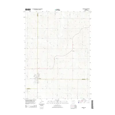
2014 Map of Emerson
USGS Topo · Published 2014About this map
Emerson sits at the unusual three-way intersection of Dixon, Dakota, and Thurston counties, anchoring a landscape shaped by rural Nebraska road grids and meandering prairie waterways. The village is well-documented with its residential core and several significant burial grounds, including Rose Hill Cem and Calvary Cem on its northwestern edge. This 2014 survey illustrates the region's reliance on a strictly rectangular network of section roads like 859th Rd and 590 Ave, which contrast sharply with the winding paths of Elk Cr and Middle Cr. Further east, the small settlement of Nacora provides a secondary point of interest along the path of Ne-35, while the secluded Jopp Cem rests near the eastern county line, offering valuable data for genealogists tracing family roots in this corner of the state.
Find a feature on this map
53 named features on this map. Tap any name to fly to it.
Don’t see what you’re looking for? This feature index may not catch every label — zoom into the map to look around manually.
Map Details
Editions of this 2014 Emerson Map
This is the sole edition of this map. No revisions or reprints were ever made.
Other maps of this area

1955 · Sioux City
USGS Topo · 1:250,000

1958 · Sioux City
USGS Topo · 1:250,000

1959 · Sioux City
USGS Topo · 1:250,000

1966 · Thurston
USGS Topo · 1:24,000

1966 · Altona NE
USGS Topo · 1:24,000

1966 · Pender NE
USGS Topo · 1:24,000

1967 · Waterbury
USGS Topo · 1:24,000
1967 · Allen
USGS Topo · 1:24,000
1967 · Jackson
USGS Topo · 1:24,000
1967 · Wakefield
USGS Topo · 1:24,000