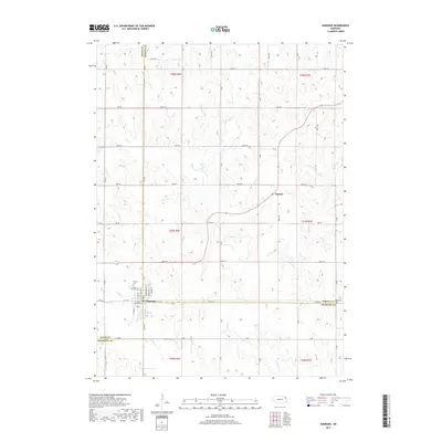
2017 Map of Emerson
USGS Topo · Published 2017About this map
Emerson sits at the intersection of three Nebraska counties, serving as a focal point where the borders of Dixon, Dakota, and Thurston meet. The settlement is anchored by local history markers including Calvary Cem and Rose Hill Cem on its northern edge, while the surrounding landscape is defined by a dendritic network of streams. Waterways like Middle Cr and N Omaha Cr carve through the agricultural sections, which are organized by a rigid grid of rural roads such as 270th St and B Ave. To the northeast, the small community of Nacora appears along the roadway leading toward the Dakota County line. This 2017 U.S. Geological Survey representation documents the persistent rural character of the region, where drainage from Elk Cr and Pigeon Cr continues to shape the productive fields between township lines.
Find a feature on this map
35 named features on this map. Tap any name to fly to it.
Don’t see what you’re looking for? This feature index may not catch every label — zoom into the map to look around manually.
Map Details
Editions of this 2017 Emerson Map
This is the sole edition of this map. No revisions or reprints were ever made.
Other maps of this area

1955 · Sioux City
USGS Topo · 1:250,000

1958 · Sioux City
USGS Topo · 1:250,000

1959 · Sioux City
USGS Topo · 1:250,000

1966 · Thurston
USGS Topo · 1:24,000

1966 · Altona NE
USGS Topo · 1:24,000

1966 · Pender NE
USGS Topo · 1:24,000

1967 · Waterbury
USGS Topo · 1:24,000
1967 · Allen
USGS Topo · 1:24,000
1967 · Jackson
USGS Topo · 1:24,000
1967 · Wakefield
USGS Topo · 1:24,000