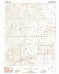
1988 Map of Emigrant Pass
USGS Topo · Published 1988About this map
Death Valley National Monument encompasses this arid, high-altitude landscape in Inyo County, where steep drainages like Nova Canyon and Nemo Canyon carve through the Panamint Range. Human activity in this unforgiving environment is centered around reliable water sources and mineral extraction. The Wildrose Ranger Station serves as an administrative hub near the Wildrose Campground, while reliable life-sustaining points are marked by Wildrose Spring and Mud Spring. Evidence of the region’s mining heritage is visible through scattered prospects and the named Christmas Mine to the east. The terrain transitions from the high Harrisburg Flats down through White Sage Flat, with transportation routes dictated by the contours of the land, most notably crossing at Emigrant Pass. This survey illustrates the isolation and essential infrastructure required to navigate and work within the desert interior.
Find a feature on this map
26 named features on this map. Tap any name to fly to it.
Don’t see what you’re looking for? This feature index may not catch every label — zoom into the map to look around manually.
Map Details
Editions of this 1988 Emigrant Pass Map
This is the sole edition of this map. No revisions or reprints were ever made.
Other maps of this area

1908 · Ballarat
USGS Topo · 1:250,000

1913 · Ballarat
USGS Topo · 1:250,000

1948 · Death Valley
USGS Topo · 1:250,000

1951 · Panamint Butte
USGS Topo · 1:62,500

1951 · Maturango Peak
USGS Topo · 1:62,500

1952 · Telescope Peak
USGS Topo · 1:62,500

1952 · Emigrant Canyon
USGS Topo · 1:62,500

1954 · Death Valley
USGS Topo · 1:250,000

1956 · Death Valley
USGS Topo · 1:250,000

1957 · Death Valley
USGS Topo · 1:250,000