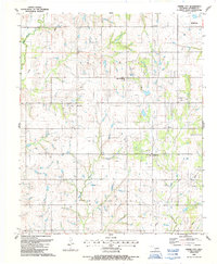
1987 Map of Empire City
USGS Topo · Published 1988About this map
Empire City and Gas City anchor this landscape in Stephens County, where the regional economy is clearly defined by the sprawling Oil Field and numerous Oil Wells. The map reveals a community structured around rural institutions, such as Empire Sch and Fair Ch, alongside the Oak Grove Cem situated just west of the main settlement. The physical geography is dominated by a complex network of waterways, including Rock Creek and Little Beaver Cr, which carve through the McPherson terrain. An extensive network of pipelines and a prominent Substation underscore the intensive industrial development of the late 20th century. This survey reflects the intersection of a petroleum-driven landscape and established rural roots, with the southern fringes of Duncan appearing in the northeast corner.
Find a feature on this map
18 named features on this map. Tap any name to fly to it.
Don’t see what you’re looking for? This feature index may not catch every label — zoom into the map to look around manually.
Map Details
Editions of this 1987 Empire City Map
This is the sole edition of this map. No revisions or reprints were ever made.
Other maps of this area

1901 · Addington
USGS Topo · 1:125,000

1902 · Rush Springs
USGS Topo · 1:125,000

1949 · Nellie
USGS Topo · 1:62,500

1950 · Marlow
USGS Topo · 1:62,500

1951 · Marlow
USGS Topo · 1:62,500

1955 · Lawton
USGS Topo · 1:250,000

1956 · Letitia
USGS Topo · 1:24,000

1956 · Nellie
USGS Topo · 1:24,000

1956 · Nellie
USGS Topo · 1:62,500

1957 · Ardmore
USGS Topo · 1:250,000