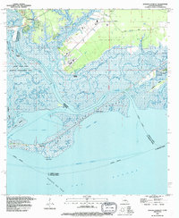
1993 Map of English Lookout
USGS Topo · Published 1995About this map
English Lookout and Pearlington sit at the watery edge of the Mississippi-Louisiana border, where the Pearl River meets the open expanse of Lake Borgne. This deltaic landscape is dominated by complex marsh systems and bayous, including Mulatto Bayou and Cross Bayou. The transition from land to sea is marked by extensive conservation lands in the Pearl River State Wildlife Management Area and industrial activity at the Ansley Gas Field.
Find a feature on this map
42 named features on this map. Tap any name to fly to it.
Don’t see what you’re looking for? This feature index may not catch every label — zoom into the map to look around manually.
Map Details
Editions of this 1993 English Lookout Map
2 editions found
Other maps of this area

1893 · Rigolets
USGS Topo · 1:62,500

1893 · Toulme
USGS Topo · 1:62,500

1914 · Nicholson
USGS Topo · 1:62,500

1921 · Nicholson
USGS Topo · 1:62,500

1935 · English Lookout
USGS Topo · 1:31,680

1935 · Grand Island Pass
USGS Topo · 1:31,680

1936 · Rigolets
USGS Topo · 1:62,500

1946 · Malheureux Point
USGS Topo · 1:31,680
1946 · Rigolets
USGS Topo · 1:31,680

1949 · Grand Island Pass
USGS Topo · 1:31,680