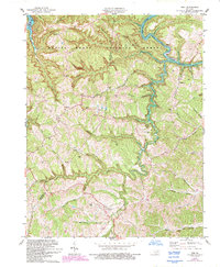
1978 Map of Ezel
USGS Topo · Published 1993About this map
Ezel serves as a focal point in this eastern Kentucky landscape, situated along the southern edge of the Daniel Boone National Forest. The map documents a rugged terrain defined by the winding course of the Licking River and its numerous tributaries, including Devil Creek and Goad Creek. Significant land use patterns are visible through the concentration of family-named burial grounds like Cecil Cem, Johnson Cem, and Whitaker Cem, which offer essential data for genealogical research in Morgan and Menifee counties. The area's recreational and industrial character is captured by the Broke Leg Falls Picnic Area and several quarries near Cave Lake. Notable landmarks like Knocking Cave and the Radio Tower near Ezel provide fixed points for navigating the deep ridges and hollows that characterize this portion of the Cumberland Plateau.
Find a feature on this map
56 named features on this map. Tap any name to fly to it.
Don’t see what you’re looking for? This feature index may not catch every label — zoom into the map to look around manually.
Map Details
Editions of this 1978 Ezel Map
2 editions found
Other maps of this area

1889 · Salyersville
USGS Topo · 1:125,000

1891 · Salyersville
USGS Topo · 1:125,000

1892 · Beattyville
USGS Topo · 1:125,000

1899 · Salyersville
USGS Topo · 1:125,000

1929 · Morehead
USGS Topo · 1:48,000

1929 · Salt Lick
USGS Topo · 1:62,500

1934 · Salt Lick
USGS Topo · 1:62,500

1935 · Morehead
USGS Topo · 1:62,500

1951 · Cannel City
USGS Topo · 1:24,000

1951 · Ezel
USGS Topo · 1:24,000