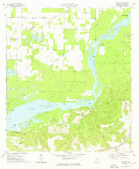
1974 Map of Faceville
USGS Topo · Published 1976About this map
Lake Flint Seminole River dominates this southwestern Georgia landscape, where the backwaters of the Flint River meet the industrial and agricultural corridors of Decatur County. In the mid-1970s, the area around Faceville and the landing at Recovery maintained a network of rural churches and cemeteries, including Mt Gilead Ch and Morning Star Cem, reflecting deep-rooted family ties to the land. The Seaboard Coast Line railroad cuts across the southern portion of the map, serving as a vital transport link near the Florida state line. The terrain transitions from the low-lying wetlands of Big Horseshoe Bend and Bass Island to the higher elevations of Curry Hill. Local landmarks like Ten Mile Still Landing and Hales Landing indicate a river-oriented economy, while scattered sites like the Gravel Pit and various boat ramps show the intersection of local industry and recreation during this era.
Find a feature on this map
35 named features on this map. Tap any name to fly to it.
Don’t see what you’re looking for? This feature index may not catch every label — zoom into the map to look around manually.
Map Details
Editions of this 1974 Faceville Map
This is the sole edition of this map. No revisions or reprints were ever made.
Other maps of this area

1954 · Desser
USGS Topo · 1:24,000

1954 · Tallahassee
USGS Topo · 1:250,000

1955 · Reynoldsville
USGS Topo · 1:24,000

1955 · Chattahoochee
USGS Topo · 1:24,000

1955 · Bainbridge
USGS Topo · 1:62,500

1955 · Mt Pleasant
USGS Topo · 1:24,000

1956 · Dogtown
USGS Topo · 1:24,000

1959 · Tallahassee
USGS Topo · 1:250,000

1960 · Tallahassee
USGS Topo · 1:250,000
1974 · Bainbridge
USGS Topo · 1:24,000