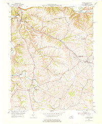
1953 Map of Fairfield
USGS Topo · Published 1976About this map
Salt River and its northern tributaries carve a complex drainage pattern through this corner of Nelson County, where the landscape is defined by the winding course of East Fork Cox Creek and Kimbly Run. The settlement of Fairfield sits as a primary hub on the eastern edge of the survey, while the community of Coxs Creek anchors the southern reaches. This early 1950s record shows a rural society centered on its institutions, from the Little Union Ch and St Michaels Ch to the Cox Creek Sch.
Find a feature on this map
26 named features on this map. Tap any name to fly to it.
Don’t see what you’re looking for? This feature index may not catch every label — zoom into the map to look around manually.
Map Details
Editions of this 1953 Fairfield Map
2 editions found

Other maps of this area

1907 · Louisville
USGS Topo · 1:62,500

1929 · Taylorsville
USGS Topo · 1:62,500

1949 · Cravens
USGS Topo · 1:24,000

1949 · Samuels
USGS Topo · 1:24,000

1949 · Shepherdsville
USGS Topo · 1:62,500

1951 · Waterford
USGS Topo · 1:24,000

1951 · Mount Washington
USGS Topo · 1:24,000
1951 · Louisville
USGS Topo · 1:62,500

1953 · Maud
USGS Topo · 1:24,000

1953 · Bardstown
USGS Topo · 1:24,000