1997 Map of Fallbrook
USGS Topo · Published 2000About this map
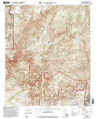
Santa Margarita y Las Flores Grant and the Santa Rosa Grant dominate this landscape, reflecting the deep Spanish and Mexican land-grant history of the region. The map reveals a transition from the rugged upland terrain of Redonda Mesa and Oak Ridge down to the fertile valleys shaped by De Luz Creek. Near the southern edge, the infrastructure of the Camp Pendleton Marine Corps Base and the Naval Weapons Station (Fallbrook Annex) indicates the area's significant military footprint.
Find a feature on this map
31 named features on this map. Tap any name to fly to it.
Don’t see what you’re looking for? This feature index may not catch every label — zoom into the map to look around manually.
Map Details
Editions of this 1997 Fallbrook Map
This is the sole edition of this map. No revisions or reprints were ever made.
Other maps of this area

1901 · Southern California Sheet No. 1
USGS Topo · 1:250,000

1901 · Elsinore
USGS Topo · 1:125,000

1901 · San Luis Rey
USGS Topo · 1:125,000

1904 · Southern California Sheet No. 2
USGS Topo · 1:250,000

1904 · Southern California Sheet No. 1
USGS Topo · 1:250,000

1941 · Margarita Peak
USGS Topo · 1:62,500

1942 · Lake Elsinore
USGS Topo · 1:62,500

1942 · Margarita Peak
USGS Topo · 1:62,500

1942 · Temecula
USGS Topo · 1:62,500

1942 · Murrieta
USGS Topo · 1:62,500
Featured Places
- Fallbrook, CA
- Marine Corps Base Camp Pendleton, CA
- Santa Margarita Groves, CA
- De Luz Heights, CA
- De Luz, CA