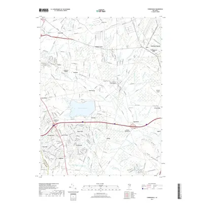
2019 Map of Farmingdale
USGS Topo · Published 2019About this map
Farmingdale and its surrounding Monmouth County townships are defined by a mix of historic borough centers and significant mid-century suburban expansion. The northern portion of the map is dominated by the sprawling naval weapons station at Earle, while the central area features the massive Manasquan Reservoir, a landmark hydrological feature that reshaped the local drainage of Bear Swamp Brook and Mingamahone Brook. Moving south, the landscape transitions into established residential developments like Freewood Acres, Salem Hill, and Land of Pines, which surround the commercial corridors of Southard. Transport history is visible through the Conrail rail lines that intersect the borough, alongside the varied course of the Manasquan River. Genealogists and local historians can find long-standing community landmarks including Evergreen Cem and Quaker Cem, alongside the Monmouth Executive Airport on the eastern edge.
Find a feature on this map
240 named features on this map. Tap any name to fly to it.
Don’t see what you’re looking for? This feature index may not catch every label — zoom into the map to look around manually.
Map Details
Editions of this 2019 Farmingdale Map
This is the sole edition of this map. No revisions or reprints were ever made.
Other maps of this area

1888 · New Brunswick
USGS Topo · 1:62,500

1888 · Asbury Park
USGS Topo · 1:62,500

1888 · Cassville
USGS Topo · 1:62,500

1888 · Sandy Hook
USGS Topo · 1:62,500

1893 · New Brunswick
USGS Topo · 1:62,500

1893 · Sandy Hook
USGS Topo · 1:62,500

1893 · Asbury Park
USGS Topo · 1:62,500

1894 · Cassville
USGS Topo · 1:62,500

1900 · Cassville
USGS Topo · 1:62,500

1901 · New Brunswick
USGS Topo · 1:62,500