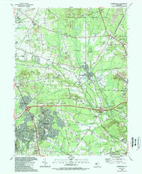
1989 Map of Farmingdale
USGS Topo · Published 1989About this map
Farmingdale serves as a central hub in this late-1980s Monmouth County landscape, where suburban expansion meets significant institutional and military installations. The northern reach is dominated by the sprawling U S Naval Weapons Station Earle, while the Manasquan River and its numerous tributaries, such as Mingamahone Brook and Marsh Bog Brook, carve through the terrain. The map captures a period of distinct residential growth in communities like Land of Pines and Candlewood, positioned near major transit corridors like the Garden State Parkway.
Find a feature on this map
81 named features on this map. Tap any name to fly to it.
Don’t see what you’re looking for? This feature index may not catch every label — zoom into the map to look around manually.
Map Details
Editions of this 1989 Farmingdale Map
This is the sole edition of this map. No revisions or reprints were ever made.
Other maps of this area

1888 · New Brunswick
USGS Topo · 1:62,500

1888 · Asbury Park
USGS Topo · 1:62,500

1888 · Cassville
USGS Topo · 1:62,500

1888 · Sandy Hook
USGS Topo · 1:62,500

1893 · New Brunswick
USGS Topo · 1:62,500

1893 · Sandy Hook
USGS Topo · 1:62,500

1893 · Asbury Park
USGS Topo · 1:62,500

1894 · Cassville
USGS Topo · 1:62,500

1900 · Cassville
USGS Topo · 1:62,500

1901 · New Brunswick
USGS Topo · 1:62,500