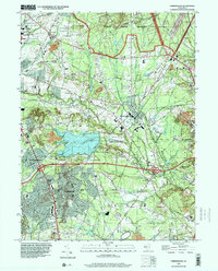
1995 Map of Farmingdale
USGS Topo · Published 2001About this map
The Earle Naval Weapons Station dominates the northern landscape of this Monmouth County region, highlighting the significant military footprint in the area during the late twentieth century. Centered on the borough of Farmingdale, the map illustrates a transition from established settlements like Jerseyville and Ardena to the preserved wooded lands of Allaire State Park in the southeast. The Manasquan River and its numerous tributaries, including Yellow Brook and Marsh Bog Brook, carve through the terrain, defining the local hydrology and providing the backdrop for recreation at Howell County Park.
Find a feature on this map
66 named features on this map. Tap any name to fly to it.
Don’t see what you’re looking for? This feature index may not catch every label — zoom into the map to look around manually.
Map Details
Editions of this 1995 Farmingdale Map
This is the sole edition of this map. No revisions or reprints were ever made.
Other maps of this area

1888 · New Brunswick
USGS Topo · 1:62,500

1888 · Asbury Park
USGS Topo · 1:62,500

1888 · Cassville
USGS Topo · 1:62,500

1888 · Sandy Hook
USGS Topo · 1:62,500

1893 · New Brunswick
USGS Topo · 1:62,500

1893 · Sandy Hook
USGS Topo · 1:62,500

1893 · Asbury Park
USGS Topo · 1:62,500

1894 · Cassville
USGS Topo · 1:62,500

1900 · Cassville
USGS Topo · 1:62,500

1901 · New Brunswick
USGS Topo · 1:62,500