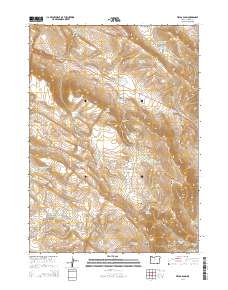
2014 Map of Fields Basin
USGS Topo · Published 2014About this map
Fields Basin and the southern reaches of the Catlow Rim define this high-desert landscape in southeastern Harney County. This 2014 survey reveals an arid environment managed for water through an extensive network of human-made catchments, including Eleven Horse Reservoir, Big Basin Reservoir, and the Sidehill Reservoir. The terrain is deeply incised by drainages such as Pearl Wise Canyon and Blair Canyon, which descend toward Fields Creek. To the south, the topography rises toward Mahogany Point and the Pueblo Mountains, where natural water sources like McDade Springs and Rincon Springs provide rare moisture. The primary artery through this isolated region is the Catlow Valley Road, which skirts the base of the dramatic western escarpments.
Find a feature on this map
43 named features on this map. Tap any name to fly to it.
Don’t see what you’re looking for? This feature index may not catch every label — zoom into the map to look around manually.
Map Details
Editions of this 2014 Fields Basin Map
This is the sole edition of this map. No revisions or reprints were ever made.
Other maps of this area

1955 · Adel
USGS Topo · 1:250,000

1957 · Adel
USGS Topo · 1:250,000

1958 · Adel
USGS Topo · 1:250,000

1962 · Adel
USGS Topo · 1:250,000

1971 · Square Mountain
USGS Topo · 1:24,000

1971 · Fields Basin
USGS Topo · 1:24,000

1971 · Garrison Lake
USGS Topo · 1:24,000

1971 · V Lake
USGS Topo · 1:24,000

1971 · Fields
USGS Topo · 1:24,000
1971 · Skull Creek Butte
USGS Topo · 1:24,000