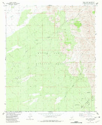
1981 Map of Fleck Draw
USGS Topo · Published 1981About this map
The White Sands Missile Range dominates this portion of the northern Chihuahuan Desert, where military and agricultural research boundaries overlap in the arid landscape. The map illustrates a high-desert environment defined by seasonal watercourses like Gilmore Draw and Fleck Draw, which have historically dictated the placement of remote outposts. Evidence of ranching and early 20th-century land use is visible through landmarks such as Fleck Ranch and Britton Camp, alongside isolated water sources like Cedar Well and Indian Tank. In the south, the Jornada Experimental Range (USDA) marks a transition into dedicated rangeland studies, connected to the north by intermittent features like Horse Draw and New Well. The presence of several Jeep Trails underscores the rugged, inaccessible nature of this high-clearance terrain during the early 1980s.
Find a feature on this map
16 named features on this map. Tap any name to fly to it.
Don’t see what you’re looking for? This feature index may not catch every label — zoom into the map to look around manually.
Map Details
Editions of this 1981 Fleck Draw Map
This is the sole edition of this map. No revisions or reprints were ever made.
Other maps of this area

1916 · Tonuco
USGS Topo · 1:125,000

1932 · Tonuco
USGS Topo · 1:125,000

1948 · Chicken Well
USGS Topo · 1:62,500

1948 · Bear Peak
USGS Topo · 1:62,500

1948 · San Diego Mountain
USGS Topo · 1:62,500

1948 · Kaylor Mountain
USGS Topo · 1:62,500

1955 · Las Cruces
USGS Topo · 1:250,000

1958 · Las Cruces
USGS Topo · 1:250,000

1981 · Gilmore Draw
USGS Topo · 1:24,000
1981 · San Andres Peak
USGS Topo · 1:24,000