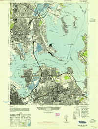
1947 Map of Flushing
USGS Topo · Published 1947About this map
Fort Schuyler and Fort Totten anchor the mouth of the East River in this postwar study of the Queens and Bronx shorelines. The landscape is defined by the rapid convergence of military, aviation, and suburban development. High-traffic corridors like the Cross Island Parkway and Whitestone Parkway carve through the residential grids of Whitestone and Bayside. Aviation history is prominent, with the massive footprint of La Guardia Field and the smaller Flushing Airport positioned near the marshy bends of the Flushing River. Local heritage is preserved in the expansive St Raymonds Cem and Flushing Cem, while the ecclesiastical presence of the Franciscan Poor Clares Monastery and St Michaels Ch marks the community's social core. To the north, Pelham Bay Park and City Island offer a contrast of open recreational space and maritime industry against the dense urban expansion.
Find a feature on this map
54 named features on this map. Tap any name to fly to it.
Don’t see what you’re looking for? This feature index may not catch every label — zoom into the map to look around manually.
Map Details
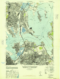
Editions of this 1947 Flushing Map
2 editions found
Other maps of this area

1889 · Brooklyn
USGS Topo · 1:62,500

1891 · Brooklyn
USGS Topo · 1:62,500

1891 · Harlem
USGS Topo · 1:62,500

1897 · Harlem
USGS Topo · 1:62,500

1897 · Brooklyn
USGS Topo · 1:62,500

1897 · Hempstead
USGS Topo · 1:62,500

1897 · Oyster Bay
USGS Topo · 1:62,500

1898 · Harlem
USGS Topo · 1:62,500

1898 · Hempstead
USGS Topo · 1:62,500

1898 · Brooklyn
USGS Topo · 1:62,500
Featured Places
- New York, NY
- North Hempstead, NY
- New Rochelle, NY
- Great Neck, North Hempstead
- Kings Point, North Hempstead