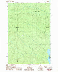
1986 Map of Fool Brook
USGS Topo · Published 1987About this map
Chemquasabamticook Lake (Ross Lake) anchors the eastern edge of this northern Maine landscape, where the convergence of several major drainage systems defines the terrain. The map captures a transition point in the Maine North Woods, where the borders of Somerset, Aroostook, and Piscataquis counties meet. A network of logging access points is evident, marked by a primary Private Road and a notable Gravel Pit used for local infrastructure. The drainage basin includes Fool Brook, Center Brook, Mills Brook, and Sweeney Brook, which together carve the topography into a series of ridges and valleys. Human presence is sparse, centered primarily around Gannett Camp near the lakeshore, illustrating the remote and specialized nature of this timber and recreation-oriented territory during the mid-1980s.
Find a feature on this map
14 named features on this map. Tap any name to fly to it.
Don’t see what you’re looking for? This feature index may not catch every label — zoom into the map to look around manually.
Map Details
Editions of this 1986 Fool Brook Map
This is the sole edition of this map. No revisions or reprints were ever made.
Other maps of this area

1954 · Baker Lake
USGS Topo · 1:62,500

1954 · Allagash Lake
USGS Topo · 1:62,500

1954 · Presque Isle
USGS Topo · 1:250,000

1955 · Beaver Pond
USGS Topo · 1:62,500

1955 · Clayton Lake
USGS Topo · 1:62,500

1958 · Presque Isle
USGS Topo · 1:250,000

1960 · Presque Isle
USGS Topo · 1:250,000

1961 · Allagash Lake
USGS Topo · 1:62,500

1962 · Baker Lake
USGS Topo · 1:62,500
1986 · Mary L Pond
USGS Topo · 1:24,000