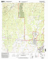
1999 Map of Fort Bayard
USGS Topo · Published 2002About this map
Pinos Altos sits at the northern edge of this Grant County landscape, where the Continental Divide winds through the Pinos Altos Range. The late 20th-century character of the region is defined by a mix of historic mining areas, indicated by numerous Prospect and Mine labels, and the established institutional presence of the Fort Bayard National Cemetery and the Fort Bayard Administrative Site. The transition from the rugged highlands of the Gila National Forest to the valley floor is marked by settlements like Arenas Valley and Santa Clara. Infrastructure including the Whiskey Creek Airport and the Cobre High Sch serves the local community, while the Continental Divide Scenic Trail follows the high ridges. Water sources such as Atlantic Creek and Cameron Creek drain toward the Rio de Arenas, illustrating the drainage patterns that shaped local development.
Find a feature on this map
58 named features on this map. Tap any name to fly to it.
Don’t see what you’re looking for? This feature index may not catch every label — zoom into the map to look around manually.
Map Details
Editions of this 1999 Fort Bayard Map
This is the sole edition of this map. No revisions or reprints were ever made.
Other maps of this area

1909 · Silver City
USGS Topo · 1:125,000

1937 · Santa Rita
USGS Topo · 1:24,000

1947 · Allie Canyon
USGS Topo · 1:24,000

1947 · Twin Sisters
USGS Topo · 1:24,000

1947 · Fort Bayard
USGS Topo · 1:24,000

1948 · Twin Sisters
USGS Topo · 1:24,000

1948 · Santa Rita
USGS Topo · 1:24,000

1948 · Allie Canyon
USGS Topo · 1:24,000

1948 · Hurley East
USGS Topo · 1:24,000

1949 · Fort Bayard
USGS Topo · 1:24,000