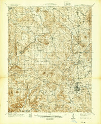
1939 Map of Fredericktown
USGS Topo · Published 1939About this map
Mining operations and granite quarrying define the landscape of the eastern Ozarks in the late 1930s. The industrial hub of Fredericktown sits at the junction of the Missouri Pacific railroad and major regional roads, surrounded by extensive mineral extraction sites. To the north, the historic Mine La Motte and the Catherine Mines reflect a legacy of lead production, while the St Joseph Lead Mines and the Missouri Granite Works underscore the area's geological wealth.
Find a feature on this map
111 named features on this map. Tap any name to fly to it.
Don’t see what you’re looking for? This feature index may not catch every label — zoom into the map to look around manually.
Map Details
Editions of this 1939 Fredericktown Map
This is the sole edition of this map. No revisions or reprints were ever made.
Other maps of this area

1904 · Farmington
USGS Topo · 1:62,500

1905 · Bonneterre
USGS Topo · 1:62,500

1906 · Farmington
USGS Topo · 1:62,500

1907 · Weingarten
USGS Topo · 1:62,500

1909 · Weingarten
USGS Topo · 1:62,500

1910 · Higdon
USGS Topo · 1:62,500
1926 · Des Arc
USGS Topo · 1:62,500
1929 · Des Arc
USGS Topo · 1:62,500
1930 · Coldwater
USGS Topo · 1:62,500

1933 · Marquand
USGS Topo · 1:62,500