
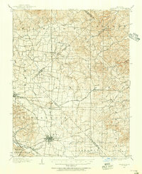
1904 Map of Farmington
USGS Topo · Published 1954About this map
Farmington serves as the focal point of this 1904 survey, situated at a vital convergence of roads and rail in eastern Missouri. The local economy and movement are defined by the St Louis Iron Mtn and Southern RR and the Illinois Southern RR, which navigate the terrain alongside historic thoroughfares like Plank Road and Hillsboro Road. This era reveals a landscape of dispersed agricultural and industrial hamlets, including French Village, Lawrenceton, and the iron-related site of Valley Forge. To the west, the foothills of the St Francois Mountains begin to rise, drained by a dense network of waterways such as Flat River and Terre Bleue Creek. For researchers, the map provides precise locations for small 19th-century settlements like Thurman and Jaydee, alongside rural cemeteries that anchor the genealogy of the region.
Find a feature on this map
52 named features on this map. Tap any name to fly to it.
Don’t see what you’re looking for? This feature index may not catch every label — zoom into the map to look around manually.
Map Details
Editions of this 1904 Farmington Map
2 editions found
Other maps of this area

1901 · De Soto
USGS Topo · 1:125,000

1905 · Bonneterre
USGS Topo · 1:62,500

1906 · Farmington
USGS Topo · 1:62,500

1907 · Weingarten
USGS Topo · 1:62,500

1909 · Weingarten
USGS Topo · 1:62,500

1910 · Higdon
USGS Topo · 1:62,500

1915 · Renault
USGS Topo · 1:62,500

1915 · Crystal City
USGS Topo · 1:62,500

1931 · De Soto SE
USGS Topo · 1:24,000

1937 · Ironton
USGS Topo · 1:48,000