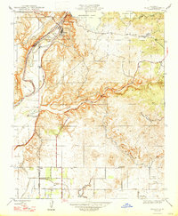
1947 Map of Friant
USGS Topo · Published 1947About this map
Friant Dam stands as the dominant engineering feat on this 1947 revision, impounding the waters of the San Joaquin River to form Millerton Lake. The settlement of Friant sits just below the dam, marking a transition from the controlled river channel and Ledger Island to the rising terrain of Owens Mountain. The map captures the infrastructure of the Central Valley at a pivotal mid-century moment, showing the Southern Pacific railroad line and the emergence of rural residential grids along Copper Avenue and Pacific Avenue.
Find a feature on this map
33 named features on this map. Tap any name to fly to it.
Don’t see what you’re looking for? This feature index may not catch every label — zoom into the map to look around manually.
Map Details
Editions of this 1947 Friant Map
This is the sole edition of this map. No revisions or reprints were ever made.
Other maps of this area

1912 · Mariposa
USGS Topo · 1:125,000

1916 · Sulphur Springs
USGS Topo · 1:24,000

1919 · Sulphur Springs
USGS Topo · 1:31,680

1919 · Little Table Mountain
USGS Topo · 1:31,680

1921 · Bullard
USGS Topo · 1:31,680

1922 · Round Mountain
USGS Topo · 1:31,680

1922 · Lanes Bridge
USGS Topo · 1:31,680

1922 · Friant
USGS Topo · 1:31,680

1923 · Academy
USGS Topo · 1:31,680

1923 · Clovis
USGS Topo · 1:31,680