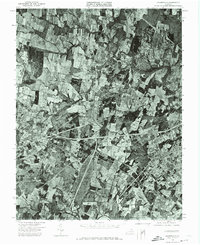
1972 Map of Gainesville
USGS Topo · Published 1974About this map
Gainesville anchors the landscape of this 1972 aerial study, appearing as a crossroads community before the surge of late-twentieth-century suburban expansion. Captured by the Commonwealth of Virginia Division of Mineral Resources and state geologist James L. Calver, the orthophotograph provides an unfiltered view of Prince William County land use. The winding course of Bull Run cuts through the northern half of the sheet, defining a natural boundary amidst a patchwork of agricultural fields and emerging transportation corridors. This orthophotoquad is particularly valuable for documenting the exact footprint of forest cover and farm boundaries prior to the heavy residential development that would soon transform this portion of Northern Virginia. It reveals the intersection of early highway systems and the rural character of the terrain surrounding the village center.
Find a feature on this map
2 named features on this map. Tap any name to fly to it.
Don’t see what you’re looking for? This feature index may not catch every label — zoom into the map to look around manually.
Map Details
Editions of this 1972 Gainesville Map
This is the sole edition of this map. No revisions or reprints were ever made.
Other maps of this area

1890 · Mt. Vernon
USGS Topo · 1:125,000

1891 · Mt. Vernon
USGS Topo · 1:125,000

1894 · Warrenton
USGS Topo · 1:125,000

1894 · Mt. Vernon
USGS Topo · 1:125,000

1897 · Mt. Vernon
USGS Topo · 1:125,000

1915 · Fairfax
USGS Topo · 1:62,500

1927 · Quantico
USGS Topo · 1:62,500

1933 · Middleburg
USGS Topo · 1:62,500

1940 · Quantico
USGS Topo · 1:62,500

1943 · Quantico
USGS Topo · 1:62,500