
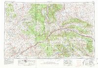
1958 Map of Gallup
USGS Topo · Published 1958About this map
Gallup serves as the focal point for this mid-century western survey, situated along the corridor of Us 66 and the Atchison Topeka and Santa Fe railroad. The landscape is defined by vast sovereign lands, including the Navajo Indian Reservation and Zuni Indian Reservation, punctuated by the volcanic and sedimentary formations of the Zuni Mountains and the Continental Divide. Regional industry is visible through the Navajo Coal Mine and Gibson Coal Mine, which reflect the area's deep ties to energy production.
Find a feature on this map
91 named features on this map. Tap any name to fly to it.
Don’t see what you’re looking for? This feature index may not catch every label — zoom into the map to look around manually.
Map Details
Editions of this 1958 Gallup Map
This is the sole edition of this map. No revisions or reprints were ever made.
Historical Maps of Gallup Through Time
6 maps found


Featured Locations
- Fort Defiance Agency
- Chinle Agency, AZ
- Fort Defiance, Fort Defiance Agency
- Window Rock, Fort Defiance Agency
- Gallup, NM