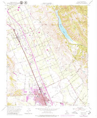
1973 Map of Gilroy
USGS Topo · Published 1979About this map
The Gilroy urban footprint expanded significantly by the early 1970s, as shown by purple photorevised updates extending south toward Old Gilroy. This agricultural and residential hub is defined by its position along the Southern Pacific railroad and the intricate drainage of Llagas Creek and its branches. To the east, the steep terrain of Larios Ridge and Sheep Ridge drops down to the expansive Coyote Lake, where the Coyote Creek valley contrasts with the grid-patterned orchards and fields of the valley floor. The map document traces a transition in land use, showing schools like St Marys Sch and Brownell Sch alongside rural landmarks like the Airway Beacon near Sun Martin. Infrastructure such as the Landing Strip and various water works highlight the region's mid-century development as it evolved from a strictly agrarian landscape into a growing suburban corridor.
Find a feature on this map
81 named features on this map. Tap any name to fly to it.
Don’t see what you’re looking for? This feature index may not catch every label — zoom into the map to look around manually.
Map Details
Editions of this 1973 Gilroy Map
This is the sole edition of this map. No revisions or reprints were ever made.
Other maps of this area

1915 · San Juan Bautista
USGS Topo · 1:48,000

1917 · Morgan Hill
USGS Topo · 1:62,500

1917 · San Juan Bautista
USGS Topo · 1:62,500

1919 · Hollister
USGS Topo · 1:48,000

1921 · Gilroy Hot Springs
USGS Topo · 1:62,500

1921 · Hollister
USGS Topo · 1:62,500

1923 · Hollister
USGS Topo · 1:62,500

1939 · Morgan Hill
USGS Topo · 1:62,500

1939 · Gilroy Hot Springs
USGS Topo · 1:62,500

1939 · San Juan Bautista
USGS Topo · 1:62,500