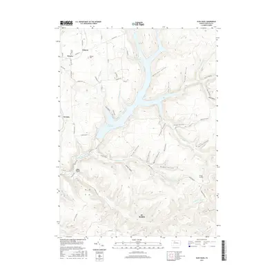
2016 Map of Glen Hazel
USGS Topo · Published 2016About this map
E Br Clarion River Lake dominates the central landscape of this Elk County region, where the East Branch Clarion River and its various forks have carved a complex system of hollows and ridges. To the north, the small settlements of Rasselas and Midmont sit near Holy Cross Cem, while the city of St. Marys anchors the southern portion of the sheet. The terrain is marked by notable elevations like Pistner Hill and N Fork Summit, reflecting the dissected plateau character typical of north-central Pennsylvania. The network of secondary roads, including Shawmut Grade Rd and Flower Valley Rd, traces the contours of the land, connecting older locales like Glen Hazel and Streights. Local history is embedded in the naming of geographic features such as Whittaker Hollow and Jenkins Hollow, alongside water sources like Carnocker Spring.
Find a feature on this map
72 named features on this map. Tap any name to fly to it.
Don’t see what you’re looking for? This feature index may not catch every label — zoom into the map to look around manually.
Map Details
Editions of this 2016 Glen Hazel Map
This is the sole edition of this map. No revisions or reprints were ever made.
Other maps of this area

1935 · Mt. Jewett
USGS Topo · 1:48,000

1940 · Mt. Jewett
USGS Topo · 1:62,500

1941 · Benezette
USGS Topo · 1:62,500

1941 · Ridgway
USGS Topo · 1:62,500

1943 · Benezette
USGS Topo · 1:62,500

1944 · Ridgway
USGS Topo · 1:62,500

1948 · Crosby
USGS Topo · 1:62,500

1948 · Wildwood Fire Tower
USGS Topo · 1:24,000
1948 · Crosby
USGS Topo · 1:24,000
1950 · Wildwood Fire Tower
USGS Topo · 1:24,000
Featured Places
- Saint Marys, PA
- Instanter, Jones Township
- Glen Hazel, Jones Township
- Streights, Jones Township
- Jones Township, PA