
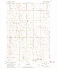
1956 Map of Glendale Colony
USGS Topo · Published 1957About this map
Glendale Colony is situated along a prominent bend of the James River in this mid-century survey of Spink County. The landscape is defined by the winding river valley and its tributary, Turtle Creek, which cuts through the eastern townships. This era of South Dakota agriculture is reflected in the dense network of rural schoolhouses spaced for local farm families, including Hughes Sch, Rosebud Sch, and the Four Corners Sch. The map also captures several educational landmarks already falling out of use, specifically the Deiter Sch and Prairie View Sch. Transport in the northern portion of the quadrangle is anchored by the Chicago and North Western railroad corridor. Notable local landmarks for genealogists include the Guttenberg Cem and several Flowing Wells that tap into the regional aquifer near the riverbanks.
Find a feature on this map
17 named features on this map. Tap any name to fly to it.
Don’t see what you’re looking for? This feature index may not catch every label — zoom into the map to look around manually.
Map Details
Editions of this 1956 Glendale Colony Map
This is the sole edition of this map. No revisions or reprints were ever made.
Other maps of this area

1895 · Byron
USGS Topo · 1:125,000

1953 · Frankfort
USGS Topo · 1:24,000

1953 · Ashton
USGS Topo · 1:24,000

1953 · Huron
USGS Topo · 1:250,000

1954 · Huron
USGS Topo · 1:250,000

1956 · Lake Byron NW
USGS Topo · 1:24,000

1956 · Spink Colony
USGS Topo · 1:24,000

1956 · Doland SW
USGS Topo · 1:24,000

1967 · Frankfort SW
USGS Topo · 1:24,000
1967 · Hitchcock
USGS Topo · 1:24,000
Featured Places
- Frankfort, SD
- Lodi Township, SD
- Frankfort Township, SD
- Lincoln Township, SD
- Glendale Hutterite Colony, SD