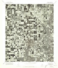
1971 Map of Glendale
USGS Topo · Published 1972About this map
Glendale and its surrounding agricultural landscape appear in this 1971 orthophoto during a period of rapid suburban expansion in the Salt River Valley. The high-altitude aerial perspective reveals a sharp contrast between the dense residential blocks of the city center and the sprawling patchwork of irrigated fields that once defined the Maricopa County interior. Stretching across the northern portion of the quadrangle, the Arizona Canal serves as the primary infrastructure dividing the emerging neighborhoods from the older farmland. To the northwest, the settlement of Peoria is clearly visible, while the southeastern corner transition into the northern reaches of Phoenix. This survey captures the precise moment when the traditional desert agricultural economy began to give way to the modern residential grid, providing an invaluable record for tracing the evolution of property lines and early subdivisions.
Find a feature on this map
4 named features on this map. Tap any name to fly to it.
Don’t see what you’re looking for? This feature index may not catch every label — zoom into the map to look around manually.
Map Details
Editions of this 1971 Glendale Map
This is the sole edition of this map. No revisions or reprints were ever made.
Other maps of this area

1912 · Phoenix
USGS Topo · 1:62,500

1914 · Phoenix
USGS Topo · 1:62,500

1946 · Avondale
USGS Topo · 1:62,500

1948 · Cashion
USGS Topo · 1:62,500

1952 · Phoenix
USGS Topo · 1:24,000

1952 · Fowler
USGS Topo · 1:24,000

1952 · Phoenix
USGS Topo · 1:62,500

1954 · Phoenix
USGS Topo · 1:250,000

1957 · Phoenix
USGS Topo · 1:250,000

1957 · Calderwood Butte
USGS Topo · 1:24,000