1935 Map of Grand Island Pass
USGS Topo · Published 1935About this map
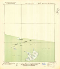
Lake Borgne and the Mississippi Sound meet in this 1935 coastal survey, depicting the complex brackish marshlands along the Louisiana and Mississippi border. Compiled from aerial photographs taken by the Air Corps, the map captures the intricate hydrology of the Grand Island Pass area before modern coastal erosion significantly altered these shorelines. The landscape is dominated by tidal features and small landmasses like Grassy Id and Lower Pt Clear, which served as critical navigation markers for mariners traversing the inner passage between the two states.
Find a feature on this map
9 named features on this map. Tap any name to fly to it.
Don’t see what you’re looking for? This feature index may not catch every label — zoom into the map to look around manually.
Map Details
Editions of this 1935 Grand Island Pass Map
2 editions found
Other maps of this area

1893 · Rigolets
USGS Topo · 1:62,500

1893 · Toulme
USGS Topo · 1:62,500

1914 · Nicholson
USGS Topo · 1:62,500

1921 · Nicholson
USGS Topo · 1:62,500

1935 · English Lookout
USGS Topo · 1:31,680

1935 · Grand Island Pass
USGS Topo · 1:31,680

1936 · Rigolets
USGS Topo · 1:62,500

1946 · Malheureux Point
USGS Topo · 1:31,680

1949 · Grand Island Pass
USGS Topo · 1:31,680

1949 · False Mouth Bayou
USGS Topo · 1:31,680