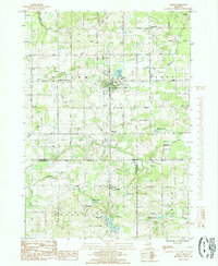
1985 Map of Grant
USGS Topo · Published 1985About this map
The town of Grant serves as the central hub of this West Michigan landscape, situated where the Chesapeake and Ohio railroad corridor intersects a grid of rural section roads. The map captures a mid-1980s transition where established agricultural communities like Ashland Center and Bailey remain anchored by local landmarks such as Bailey Gospel Ch and the North Casnovia Sch. Small water bodies and lowlands, including Blanch Lake and Skipperville Lake, interrupt the tillable fields, while several cemeteries, such as Parkview Cem and Danish Cem, provide critical touchstones for local genealogical research. Transportation is a key theme, ranging from the heavy rail line to specialized aviation sites like Grant Airport and the Tyrone Landing Strip. The presence of numerous small family-named cemeteries and crossroads settlements like Skipperville and Walter reflects the deep-rooted parceling of Newaygo, Muskegon, and Kent counties.
Find a feature on this map
59 named features on this map. Tap any name to fly to it.
Don’t see what you’re looking for? This feature index may not catch every label — zoom into the map to look around manually.
Map Details
Editions of this 1985 Grant Map
This is the sole edition of this map. No revisions or reprints were ever made.
Other maps of this area

1918 · Cedar Springs
USGS Topo · 1:62,500

1943 · Cedar Springs
USGS Topo · 1:62,500

1945 · Ravenna
USGS Topo · 1:62,500

1954 · Midland
USGS Topo · 1:250,000

1958 · Midland
USGS Topo · 1:250,000

1958 · Sand Lake
USGS Topo · 1:62,500

1958 · Fremont
USGS Topo · 1:62,500

1959 · Midland
USGS Topo · 1:250,000

1966 · Midland
USGS Topo · 1:250,000

1967 · Sparta
USGS Topo · 1:24,000