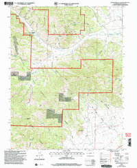
2001 Map of Graveyard Gulch
USGS Topo · Published 2005About this map
Parkville (Site) sits at the confluence of several steep drainages in this pocket of the Rio Grande National Forest, serving as a silent reminder of the area's mining history. The landscape is defined by a dense network of gulches and mineral exploration, including the Pershing Mine, E-D Mine, and numerous unnamed Prospects and Drill Holes. These operations once sought resources along the flanks of Whale Hill and Saguache Peak, relying on a complex web of 4wd tracks that still wind through the terrain. The presence of specialized camps like Whites Cam and various isolated water sources, such as Asterhouse Spring and Soda Spring, highlights the remote nature of these industrial outposts during their years of activity.
Find a feature on this map
53 named features on this map. Tap any name to fly to it.
Don’t see what you’re looking for? This feature index may not catch every label — zoom into the map to look around manually.
Map Details
Editions of this 2001 Graveyard Gulch Map
This is the sole edition of this map. No revisions or reprints were ever made.
Other maps of this area

1954 · Pueblo
USGS Topo · 1:250,000

1956 · Montrose
USGS Topo · 1:250,000

1957 · Pueblo
USGS Topo · 1:250,000

1958 · Pueblo
USGS Topo · 1:250,000

1959 · Montrose
USGS Topo · 1:250,000

1959 · Bonanza
USGS Topo · 1:62,500

1959 · Howard
USGS Topo · 1:62,500

1960 · Montrose
USGS Topo · 1:250,000

1962 · Pueblo
USGS Topo · 1:250,000

1966 · Pueblo
USGS Topo · 1:250,000