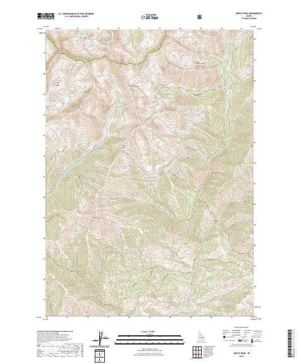
2023 Map of Grays Peak
USGS Topo · Published 2023About this map
Pioneer Mountains high peaks dominate this interior Idaho terrain, where the boundary between the Challis National Forest and Sawtooth National Forest traverses several prominent summits. The landscape is defined by its dramatic relief, featuring Grays Peak and Old Hyndman Peak overlooking deep glacial basins and high-altitude water bodies such as Arrowhead Lake and Windy Lake. This high country serves as a critical watershed, feeding the headwaters of the East Fork Wood River and the Little Wood River.
Find a feature on this map
52 named features on this map. Tap any name to fly to it.
Don’t see what you’re looking for? This feature index may not catch every label — zoom into the map to look around manually.
Map Details
Editions of this 2023 Grays Peak Map
This is the sole edition of this map. No revisions or reprints were ever made.
Other maps of this area

1895 · Hailey
USGS Topo · 1:125,000

1897 · Hailey
USGS Topo · 1:125,000

1935 · MacKay
USGS Topo · 1:96,000

1955 · Idaho Falls
USGS Topo · 1:250,000

1955 · Hailey
USGS Topo · 1:250,000

1958 · Idaho Falls
USGS Topo · 1:250,000

1959 · Hailey
USGS Topo · 1:250,000
1960 · Muldoon Canyon
USGS Topo · 1:62,500
1960 · Copper Basin
USGS Topo · 1:62,500

1962 · Hailey
USGS Topo · 1:250,000