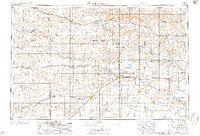
1957 Map of Great Bend
USGS Topo · Published 1957About this map
The Arkansas River and Smoky Hill River define the agricultural and industrial corridors of central Kansas in this mid-century survey. Major transportation arteries follow the water, with the Union Pacific and Missouri Pacific railroads linking established grain and cattle hubs like Great Bend, Hays, and Ellsworth. The landscape reveals the expansion of postwar infrastructure through the presence of large-scale water management projects, including the Cedar Bluff Reservoir on the Smoky Hill River and the Kanopolis Reservoir to the east.
Find a feature on this map
106 named features on this map. Tap any name to fly to it.
Don’t see what you’re looking for? This feature index may not catch every label — zoom into the map to look around manually.
Map Details
Editions of this 1957 Great Bend Map
This is the sole edition of this map. No revisions or reprints were ever made.
Other maps of this area
1889 · Cheney
USGS Topo · 1:125,000
1889 · Larned
USGS Topo · 1:125,000
1889 · Kinsley
USGS Topo · 1:125,000
1891 · Great Bend
USGS Topo · 1:125,000
1891 · Larned
USGS Topo · 1:125,000
1891 · Hutchinson
USGS Topo · 1:125,000
1891 · Cheney
USGS Topo · 1:125,000
1892 · Ness
USGS Topo · 1:125,000
1892 · Kinsley
USGS Topo · 1:125,000
1892 · Salina
USGS Topo · 1:125,000