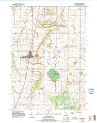
1992 Map of Greenleaf
USGS Topo · Published 1996About this map
Greenleaf stands as a central settlement in this early 1990s survey, defined by its position along the rail corridor and the nearby industrial Quarry. The landscape reflects a mix of dairy-land heritage and modern infrastructure, where the East River winds through the townships of Wrightstown, Rockland, and Holland. The presence of the Holland State Wildlife Area highlights the preservation of wetlands amidst the grid of agricultural roads, while the local aviation history is marked by a Landing Strip just north of Shirley Road. Genealogists and local historians can trace legacy sites like St Johns Cem and Fairview Cem, alongside community landmarks such as Skeeter Park and the Hilly Haven Golf Course. The map captures a moment of transition as traditional farm roads like Military Road and Townline Road continue to serve as the backbone for the small communities of Askeaton and the surrounding rural districts.
Find a feature on this map
48 named features on this map. Tap any name to fly to it.
Don’t see what you’re looking for? This feature index may not catch every label — zoom into the map to look around manually.
Map Details
Editions of this 1992 Greenleaf Map
This is the sole edition of this map. No revisions or reprints were ever made.
Other maps of this area

1954 · De Pere
USGS Topo · 1:62,500

1954 · Denmark
USGS Topo · 1:62,500

1954 · De Pere
USGS Topo · 1:24,000

1954 · Chilton
USGS Topo · 1:62,500

1954 · Reedsville
USGS Topo · 1:62,500

1954 · Manitowoc
USGS Topo · 1:250,000

1954 · Bellevue
USGS Topo · 1:24,000

1955 · Green Bay
USGS Topo · 1:250,000

1958 · Manitowoc
USGS Topo · 1:250,000

1974 · Hilbert
USGS Topo · 1:24,000