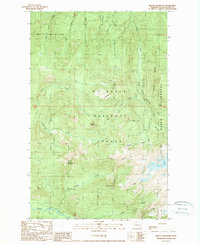
1989 Map of Groat Mountain
USGS Topo · Published 1989About this map
Groat Mountain and Lookout Mountain anchor this late-twentieth-century study of the high-elevation terrain within the Mt Baker National Forest. The landscape is defined by the drainage systems of the Middle Fork Nooksack River and Glacier Creek, which are fed by numerous tributaries including Cornell Creek and Wallace Creek. Industrial history is represented by a Coal Mine located near the headwaters of Coal Creek and the high passage of Coal Pass.
Find a feature on this map
32 named features on this map. Tap any name to fly to it.
Don’t see what you’re looking for? This feature index may not catch every label — zoom into the map to look around manually.
Map Details
Editions of this 1989 Groat Mountain Map
This is the sole edition of this map. No revisions or reprints were ever made.
Other maps of this area

1909 · Mt Baker
USGS Topo · 1:192,000

1915 · Mt. Baker
USGS Topo · 1:250,000

1919 · Van Zandt
USGS Topo · 1:62,500

1921 · Wickersham
USGS Topo · 1:62,500

1951 · Wickersham
USGS Topo · 1:62,500

1951 · Van Zandt
USGS Topo · 1:62,500

1952 · Mt. Baker
USGS Topo · 1:62,500

1952 · Hamilton
USGS Topo · 1:62,500

1955 · Concrete
USGS Topo · 1:250,000

1957 · Victoria
USGS Topo · 1:250,000