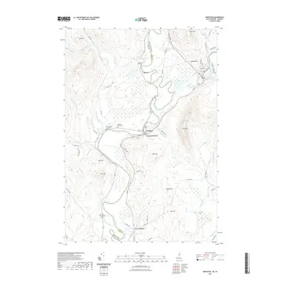
2021 Map of Groveton
USGS Topo · Published 2021About this map
The Connecticut River serves as the winding boundary between New Hampshire and Vermont in this detailed survey of the Upper Connecticut River Valley. The area is anchored by the community of Groveton, where the Upper Ammonoosuc River meets the larger waterway, and the village of Guildhall, which remains home to the Essex County Courthouse. This landscape is characterized by a high density of small family and community burial grounds, including the Keith - Crawford - North Burial Ground and the Riverside - Smart - Fellows - South Cem, which provide significant genealogical data points for the region. Significant elevation changes are marked by Bald Mtn and Morse Mtn to the north, while the floodplains below are defined by smaller settlements like Northumberland and Coos Junction. The map also captures local infrastructure such as the Groveton Bridge and numerous brooks like Dutton Brook and Roaring Brook that drain the surrounding highlands.
Find a feature on this map
71 named features on this map. Tap any name to fly to it.
Don’t see what you’re looking for? This feature index may not catch every label — zoom into the map to look around manually.
Map Details
Editions of this 2021 Groveton Map
This is the sole edition of this map. No revisions or reprints were ever made.
Other maps of this area

1893 · Mt. Washington
USGS Topo · 1:62,500

1896 · Mt. Washington
USGS Topo · 1:62,500

1900 · Whitefield
USGS Topo · 1:62,500

1920 · Guildhall
USGS Topo · 1:62,500

1930 · Percy
USGS Topo · 1:62,500

1931 · Guildhall
USGS Topo · 1:48,000

1933 · Guildhall
USGS Topo · 1:48,000

1934 · Percy
USGS Topo · 1:62,500

1935 · Whitefield
USGS Topo · 1:48,000

1935 · Mt. Washington
USGS Topo · 1:62,500