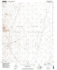
1996 Map of Gurli Put Vo
USGS Topo · Published 2001About this map
Tohono O'odham Indian Reservation lands dominate this mid-1990s terrain study, where the arid Santa Rosa Valley meets the rising slopes of the Brownell Mountains. The map documents a landscape defined by water scarcity and historical industry, with life centered around scattered water sources like Brownell Well and San Tomas Well. Traces of habitation and commerce appear at the Quijotoa Trading Post and the nearby Cemetery, while the ephemeral drainage of Quijotoa Wash and Ak Chin Wash patterns the desert floor. The map marks the Gurli Put Vo (Site), suggesting a location of historical significance within the reservation boundaries. Mining activity, a recurring theme in this part of Pima County, is evidenced by the Prospect V-O Mine, several unnamed prospects, and a Gravel Pit, illustrating the region's long-standing connection to mineral extraction.
Find a feature on this map
16 named features on this map. Tap any name to fly to it.
Don’t see what you’re looking for? This feature index may not catch every label — zoom into the map to look around manually.
Map Details
Editions of this 1996 Gurli Put Vo Map
This is the sole edition of this map. No revisions or reprints were ever made.
Other maps of this area

1934 · Silver Bell
USGS Topo · 1:125,000

1937 · Comobabi
USGS Topo · 1:48,000

1942 · Comobabi
USGS Topo · 1:62,500

1953 · Ajo
USGS Topo · 1:250,000

1956 · Tucson
USGS Topo · 1:250,000

1957 · Ajo
USGS Topo · 1:250,000

1958 · Ajo
USGS Topo · 1:250,000

1958 · Tucson
USGS Topo · 1:250,000

1959 · Tucson
USGS Topo · 1:250,000

1962 · Ajo
USGS Topo · 1:250,000