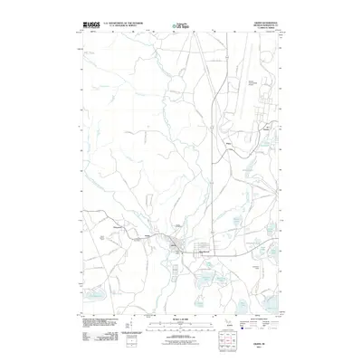
2011 Map of Gwinn
USGS Topo · Published 2011About this map
The Escanaba River and its multiple branches define the geography of this central Upper Peninsula landscape, where the settlements of Gwinn, New Swanzy, Princeton, and Austin form a cluster of residential and civic activity. This area is heavily influenced by its industrial and military history, as seen in the presence of KI Sawyer and the sprawling infrastructure of the Sawyer International Airport. Local landmarks such as the Gwinn Post Office and Princeton Post Office anchor the community centers, while the Gwinn Cemetery and Gwinn Lookout Tower provide points of interest for local historians. The map also reveals the legacy of iron mining in the region, indicated by Francis Mine Dr. Numerous water bodies, including Little Shag Lake and Johnson Lake, are interspersed among the town sites, illustrating the integration of the natural environment with early twentieth-century town planning.
Find a feature on this map
103 named features on this map. Tap any name to fly to it.
Don’t see what you’re looking for? This feature index may not catch every label — zoom into the map to look around manually.
Map Details
Editions of this 2011 Gwinn Map
This is the sole edition of this map. No revisions or reprints were ever made.
Other maps of this area

1932 · Helena NW
USGS Topo · 1:31,680

1932 · Helena NE
USGS Topo · 1:31,680

1932 · Harvey NW
USGS Topo · 1:31,680

1932 · Harvey SE
USGS Topo · 1:31,680

1932 · Harvey SW
USGS Topo · 1:31,680

1932 · Harvey NE
USGS Topo · 1:31,680

1951 · Helena NE
USGS Topo · 1:31,680

1951 · Helena NW
USGS Topo · 1:31,680

1952 · Sands
USGS Topo · 1:24,000

1952 · Ishpeming
USGS Topo · 1:62,500