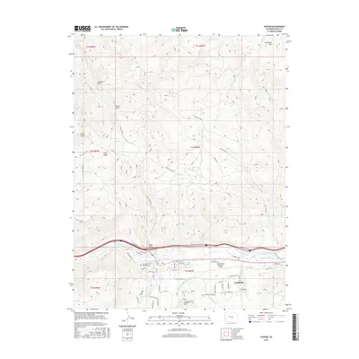
2016 Map of Gypsum
USGS Topo · Published 2016About this map
Gypsum serves as the focal point of this Eagle County landscape, situated where Gypsum Creek joins the Eagle River. The 2016 terrain is defined by a sophisticated network of irrigation systems critical to the valley's development, including the Chatfield and Bartholomew Ditch, Casper Schumm Ditch, and Stemme and Gates Ditch. These waterways trace the lower elevations near the Eagle County Regional Airport, while the northern reaches of the map climb toward Greenhorn Mountain. Local history is anchored by the Cedar Hill Memorial Cemetery and numerous named drainages like Greenhorn Gulch and Tenderfoot Gulch. The settlement pattern reflects modern expansion along the river corridor, with residential areas such as Cotton Ranch and various industrial sites supporting the regional transportation hub.
Find a feature on this map
59 named features on this map. Tap any name to fly to it.
Don’t see what you’re looking for? This feature index may not catch every label — zoom into the map to look around manually.
Map Details
Editions of this 2016 Gypsum Map
This is the sole edition of this map. No revisions or reprints were ever made.
Other maps of this area
1927 · Glenwood Springs
USGS Topo · 1:125,000
1930 · Glenwood Springs
USGS Topo · 1:125,000
1957 · Leadville
USGS Topo · 1:250,000
1959 · Leadville
USGS Topo · 1:250,000
1960 · Leadville
USGS Topo · 1:250,000
1961 · Cottonwood Pass
USGS Topo · 1:24,000
1962 · Leadville
USGS Topo · 1:250,000
1962 · Gypsum
USGS Topo · 1:24,000
1962 · Suicide Mountain
USGS Topo · 1:24,000
1962 · Eagle
USGS Topo · 1:24,000