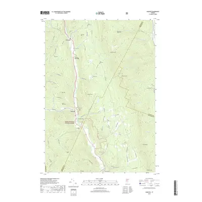
2018 Map of Hancock
USGS Topo · Published 2018About this map
The White River valley carves through the center of this terrain, anchoring the mountain settlements of Hancock and Granville. This landscape is defined by its numerous cemeteries and mountain gaps, with the Green Mountain National Forest covering much of the western half. Genealogists will find a wealth of burial sites along the valley roads, including the Village Cem, Old Village Cem, and Elmwood Cem. The geography is shaped by significant peaks and ridges like Hancock Mtn, Cobble Hill, and the Northfield Mountains. Tributaries such as Thatcher Brook and Tunnel Brook drain the steep slopes toward the river, while local routes like Post Office Hill and Town Line Rd connect the scattered homesteads. The inclusion of the Hancock Tunnel and landmarks like Thunder Head suggests a region where transportation and topography have long been intertwined.
Find a feature on this map
79 named features on this map. Tap any name to fly to it.
Don’t see what you’re looking for? This feature index may not catch every label — zoom into the map to look around manually.
Map Details
Editions of this 2018 Hancock Map
This is the sole edition of this map. No revisions or reprints were ever made.
Other maps of this area

1915 · Rochester
USGS Topo · 1:62,500

1917 · Rochester
USGS Topo · 1:62,500

1919 · Royalton
USGS Topo · 1:62,500

1919 · Lincoln Mountain
USGS Topo · 1:62,500

1920 · Lincoln Mountain
USGS Topo · 1:48,000

1921 · Lincoln Mountain
USGS Topo · 1:62,500

1922 · Barre
USGS Topo · 1:48,000

1924 · Barre
USGS Topo · 1:62,500

1924 · Randolph
USGS Topo · 1:48,000

1926 · Randolph
USGS Topo · 1:62,500