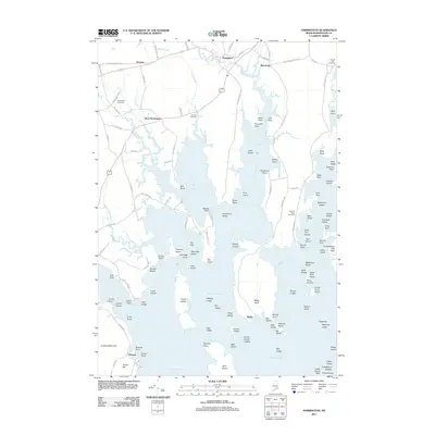
2011 Map of Harrington
USGS Topo · Published 2011About this map
Harrington and West Harrington anchor a landscape defined by the intricate tidal reaches of Washington County, where the Harrington River meets the expansive Harrington Bay. This 2011 survey records the enduring settlement patterns of the Down East coast, from the cluster of homes at Marshville to the southern point of Wyman. The map is particularly useful for genealogical research, documenting several burial sites including Church Hill Cemetery and Rock Maple Cemetery along with family-named coastal features like Nash Point and Coffins Point. The transition from freshwater to marine environments is clear, as Curtis Creek and Cole Creek drain into the tidal basins. This geography fostered a legacy of maritime reliance, evident in the numerous named ledges and islands such as Muscle Shoal and the Birch Islands that dot the navigation-heavy waters of Pleasant Bay.
Find a feature on this map
134 named features on this map. Tap any name to fly to it.
Don’t see what you’re looking for? This feature index may not catch every label — zoom into the map to look around manually.
Map Details
Editions of this 2011 Harrington Map
This is the sole edition of this map. No revisions or reprints were ever made.
Other maps of this area

1902 · Cherryfield
USGS Topo · 1:62,500

1904 · Cherryfield
USGS Topo · 1:62,500

1904 · Petit Manan
USGS Topo · 1:62,500

1921 · Great Wass Island
USGS Topo · 1:62,500

1921 · Columbia Falls
USGS Topo · 1:62,500

1921 · Columbia Falls
USGS Topo · 1:62,500

1941 · Columbia Falls
USGS Topo · 1:62,500

1942 · Cherryfield
USGS Topo · 1:62,500

1942 · Columbia Falls
USGS Topo · 1:62,500
1948 · Columbia Falls
USGS Topo · 1:24,000