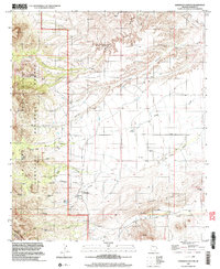
1996 Map of Harrison Canyon
USGS Topo · Published 2003About this map
Coronado National Forest and the Galiuro Wilderness dominate this high-desert landscape in Graham County during the mid-1990s. The terrain is defined by the sharp rise of the Galiuro Mountains and the rolling Black Hills, where water management is the primary marker of human presence. An extensive network of tanks and small dams, such as Rincon Dam, Harrison Canyon Dam, and Oak Creek Dam, supports the arid environment alongside named water sources like Renee Spring.
Find a feature on this map
36 named features on this map. Tap any name to fly to it.
Don’t see what you’re looking for? This feature index may not catch every label — zoom into the map to look around manually.
Map Details
Editions of this 1996 Harrison Canyon Map
This is the sole edition of this map. No revisions or reprints were ever made.
Other maps of this area

1938 · Galiuro Mts
USGS Topo · 1:48,000

1940 · Sierra Bonita Ranch
USGS Topo · 1:62,500

1942 · Sierra Bonita Ranch
USGS Topo · 1:62,500

1943 · Galiuro Mts
USGS Topo · 1:62,500

1943 · Sierra Bonita Ranch
USGS Topo · 1:62,500

1943 · Winchester Mts.
USGS Topo · 1:62,500

1945 · Redington
USGS Topo · 1:62,500

1945 · Winchester Mts.
USGS Topo · 1:62,500

1956 · Tucson
USGS Topo · 1:250,000

1957 · Redington
USGS Topo · 1:62,500