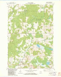
1982 Map of Hatley
USGS Topo · Published 1982About this map
Hatley and Norrie anchor this central Wisconsin landscape, where the Chicago and North Western railroad corridor shapes the local geography. The area is defined by its glacial hydrology, featuring a string of distinct water bodies such as Norrie Lake, Mayflower Lake, Mud Lake, and the curiously named Go-To-It Lake. The Plover River winds through the center, protected in part by the Plover River State Fishery Area, while the Eau Claire River cuts across the northwestern corner. Local heritage is preserved in sites like the St Florian Sch Cem, which combines educational and memorial functions, alongside the Hillcrest Cem and St Francis Cem. This 1982 revision captures the transition from small-town railroad settlements to a landscape focused on conservation and recreation, evidenced by the numerous public access points and the local Townhall.
Find a feature on this map
38 named features on this map. Tap any name to fly to it.
Don’t see what you’re looking for? This feature index may not catch every label — zoom into the map to look around manually.
Map Details
Editions of this 1982 Hatley Map
This is the sole edition of this map. No revisions or reprints were ever made.
Other maps of this area

1899 · Wausau
USGS Topo · 1:125,000

1902 · Wausau
USGS Topo · 1:125,000

1951 · Doering
USGS Topo · 1:48,000

1952 · Antigo
USGS Topo · 1:48,000

1953 · Hatley
USGS Topo · 1:48,000

1954 · Wittenberg
USGS Topo · 1:48,000

1954 · Iron Mountain
USGS Topo · 1:250,000

1955 · Green Bay
USGS Topo · 1:250,000

1959 · Iron Mountain
USGS Topo · 1:250,000

1964 · Wittenberg
USGS Topo · 1:62,500