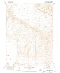
1971 Map of Hawks Mountain
USGS Topo · Published 1974About this map
Hawks Valley and the high desert terrain of southern Oregon dominate this 1971 survey, where the scarcity of water is written into the names of every landmark. The map detail highlights a series of essential livestock and wildlife stops, from Horn Waterhole in the north to Dry Lake Waterhole at the southern edge of the sheet. Remote ranching infrastructure is evident in the presence of the Hawks Valley Airstrip and numerous Jeep Trails that navigate the high plateaus like Big Spring Table.
Find a feature on this map
23 named features on this map. Tap any name to fly to it.
Don’t see what you’re looking for? This feature index may not catch every label — zoom into the map to look around manually.
Map Details
Editions of this 1971 Hawks Mountain Map
This is the sole edition of this map. No revisions or reprints were ever made.
Other maps of this area

1886 · Disaster
USGS Topo · 1:250,000

1889 · Long Valley
USGS Topo · 1:250,000

1893 · Disaster
USGS Topo · 1:250,000

1954 · Vya
USGS Topo · 1:250,000

1955 · Adel
USGS Topo · 1:250,000

1957 · Adel
USGS Topo · 1:250,000

1958 · Vya
USGS Topo · 1:250,000

1958 · Adel
USGS Topo · 1:250,000

1962 · Vya
USGS Topo · 1:250,000

1962 · Adel
USGS Topo · 1:250,000